
|
|
|
Geologic Disaster
1. Journey to the centre of the Earth
"What's inside the Earth?"
Watch the movie, journey to the centre of the Earth. Can this be true?
We're going to explore what the Earth is really like on the inside.
1. Complete the worksheet below on a piece of A3 paper.
2. Annotate and colour the A3 paper using the information below.
3. Paste the paper into your book.
We're going to explore what the Earth is really like on the inside.
1. Complete the worksheet below on a piece of A3 paper.
2. Annotate and colour the A3 paper using the information below.
3. Paste the paper into your book.
| Earth Pizza Slice |
Resources: You'll need flash player for these.
|
| |||||
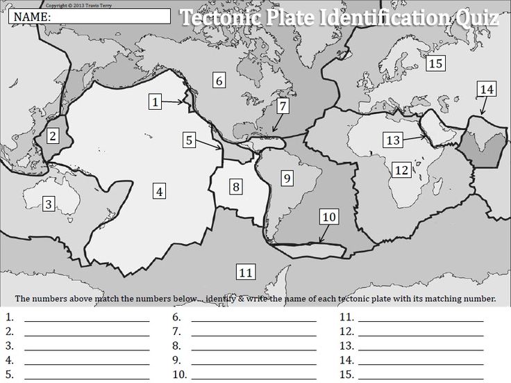
2. "It's breaking up?"
Plate Distrubution
1. First let's look at the crust of the Earth. How do we know it's moving? We know this because volcanoes and earthquakes are associated with plate margins (plate = pieces of the crust & margin = edges of the plates). Let's look at the correlation.
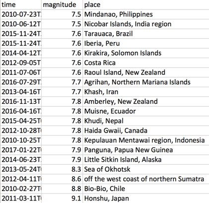
2. On the map provided, use Google Earth to mark the position of the volcano and earthquakes below.
| Earth Plate Margins map |
3. Fill in the names of the plates on the bottom of the worksheet.
|
Active Volcanoes
|
Recent Major Earthquakes
|
4. Answer the following question in your book. Is Hong Kong going anywhere?
Below is an infographic of Hong Kong's geologic history. The city has had an interesting past. What does Sai Kung look like on a map?
Below is an infographic of Hong Kong's geologic history. The city has had an interesting past. What does Sai Kung look like on a map?
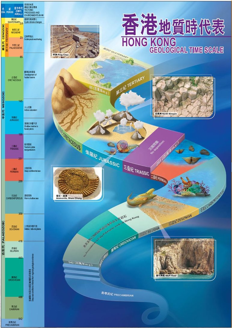
image source: CEDD HK
3. Plate Margins
There are four types of plate margins found along the crust.
A constructive plate boundary is when two plates are pulled apart to form rift valleys. On continental plates, these form deep lakes like Lake Victoria on the African continent. Over time, these may form seas like the Red Sea which separates Africa and the Middle East. On oceanic plates, these will allow magma to rise up and stick to the separating plates. This creates new land.
A collision plate boundary is when two continental plates collide together. This creates folds and increases the thickness of the plates by building mountains like the Himalayas where the Indian plate is pushing its way into the Eurasian plate.
The Conservative plate is occurs where plates slide past each other in opposite directions, or in the same direction but at different speeds like the San Andreas fault that runs along the state of California. Friction holds the plates together until the friction is no longer enough to keep them together. The plates slip past in a sudden movement and the shockwaves created produce an earthquake.
- Constructive,
- Destructive,
- Collision &
- Conservative
A constructive plate boundary is when two plates are pulled apart to form rift valleys. On continental plates, these form deep lakes like Lake Victoria on the African continent. Over time, these may form seas like the Red Sea which separates Africa and the Middle East. On oceanic plates, these will allow magma to rise up and stick to the separating plates. This creates new land.
A collision plate boundary is when two continental plates collide together. This creates folds and increases the thickness of the plates by building mountains like the Himalayas where the Indian plate is pushing its way into the Eurasian plate.
The Conservative plate is occurs where plates slide past each other in opposite directions, or in the same direction but at different speeds like the San Andreas fault that runs along the state of California. Friction holds the plates together until the friction is no longer enough to keep them together. The plates slip past in a sudden movement and the shockwaves created produce an earthquake.
|
| ||||
Task: Complete the plate boundary worksheet
- For the worksheet below, make an annotated diagram of each plate boundary. Use the information from the button websites and the interactive flash activities. (The "Interactive plate boundaries" is my favourite.) Once you've completed the diagram, write a description about the boundary including the possibility of volcanoes or earthquakes, the frequency of volcanic eruption or earthquake and a detailed description about what's happening.
- For the worksheet below, make an annotated diagram of each plate boundary. Use the information from the button websites and the interactive flash activities. (The "Interactive plate boundaries" is my favourite.) Once you've completed the diagram, write a description about the boundary including the possibility of volcanoes or earthquakes, the frequency of volcanic eruption or earthquake and a detailed description about what's happening.
| plate boundary worksheet.pdf |
4. Volcanoes
A volcano is a feature on the Earth's crust through which lava, ash, rock and gases erupt. The Earth's crust is broken up into tectonic plates and these plates float on a layer of magma, the semi-liquid rock and dissolved gases of the mantle and outer core. At the boundaries of the plates, magma, which is lighter than the surrounding solid rock, is often able to force its way up through cracks and faults in the plate. In a volcano, magma can either explode from a vent or it can flow out like an overflowing cup.
4.1 Exploring volcanoes 360 view. (Feel free to use your mobile phone for these)
|
|
|
4.2 Make a model volcano
| volcano_model.pdf |
4.3 Types of volcanoes activity
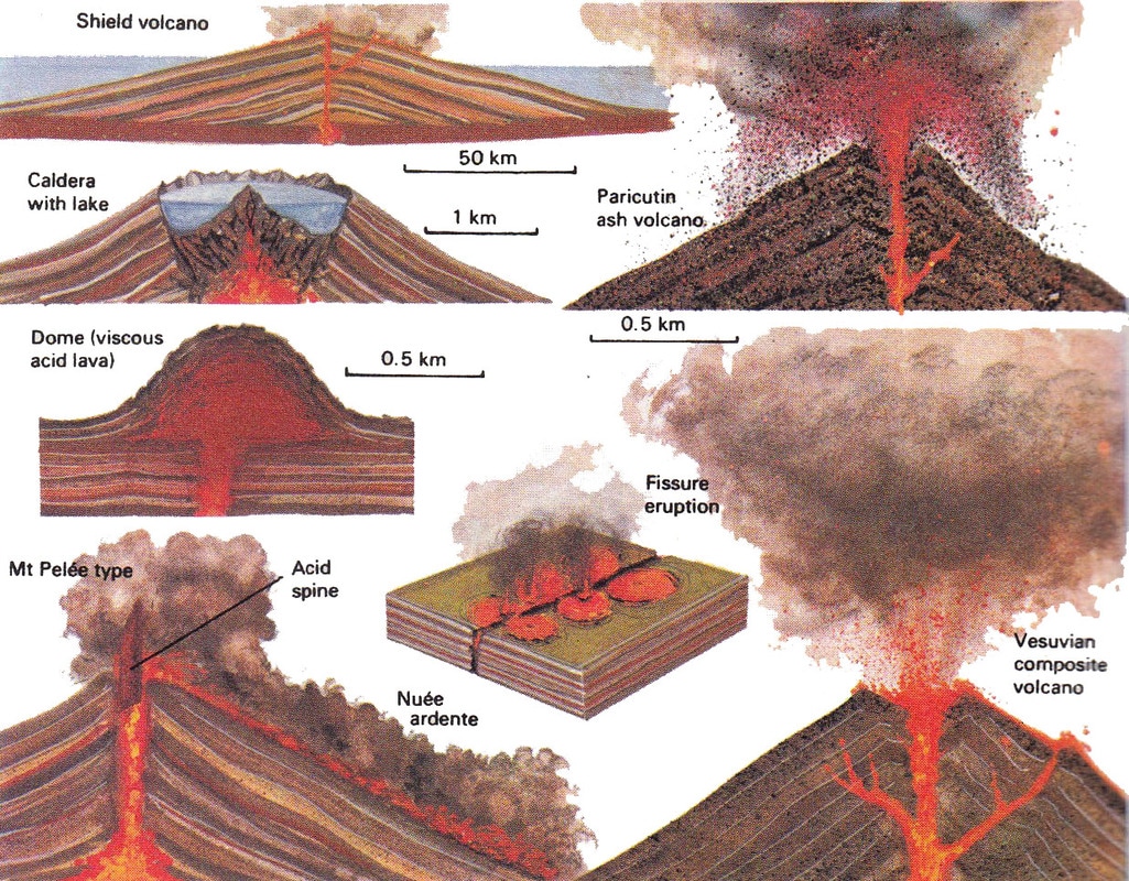
source: http://bankofinfo.com/wp-content/uploads/2014/09/what_types_of_volcanoes_are_there.jpg
|
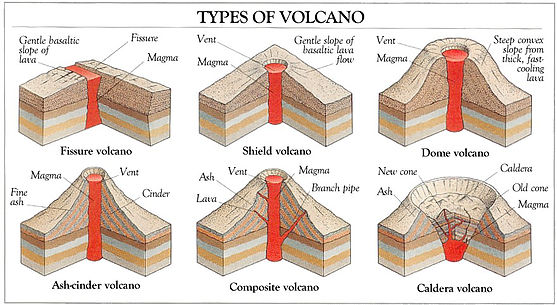
Source: http://www.suparco.gov.pk/assets/images/volcanoes.jpg
|
Use the Volcano World website to find out what type of volcano the following list are.
Copy the list of volcanoes in your book and research what type of volcano they are. If you've done the background work, you can tell just by looking at it on Google Maps.
You also need to use the Volcano World website to find examples of a Fissure volcano (aka Fissure Vent), Dome volcano (aka Lava Dome) and Ash-cinder volcano (aka Cinder Cone) and add these to your list.
- Avachinsky-Koryaksky, Kamchatka, Russia
- Colima, Jalisco and Colima, Mexico
- Mount Etna, Sicily, Italy
- Galeras, Nariño, Colombia
- Mauna Loa, Hawaii, USA
- Mount Merapi, Central Java, Indonesia
- Mount Nyiragongo, Democratic Republic of the Congo
- Mount Rainier, Washington, US
- Sakurajima, Kagoshima Prefecture, Japan
- Santorini, Cyclades, Greece
- Taal Volcano, Luzon, Philippines
- Ulawun, New Britain, Papua New Guinea
- Mount Unzen, Nagasaki Prefecture, Japan
- Vesuvius, Naples, Italy
5. Volcanic Hazards
6. Anatomy of a volcano & building competition
6.1 What's going on here?
You need to write 3 sentences to describe what you see here.
You need to write 3 sentences what you think is happening here.
You need to write 3 sentences to predict what's happening here.
You need to write 3 sentences to describe what you see here.
You need to write 3 sentences what you think is happening here.
You need to write 3 sentences to predict what's happening here.
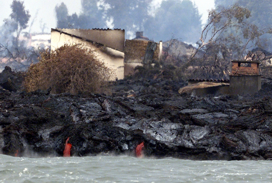
image source: https://www.pri.org/stories/2016-05-02/one-africas-most-active-volcanos-showing-new-signs-life
First! Let's look at Nyiragongo in the Democratic Republic of the Congo.
|
| ||||
6.2 Let's make our own volcano
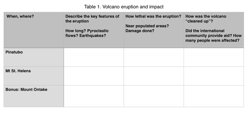
7. Dealing with an eruption: LEDC (Pinatub0) vs. MEDC (Mt. St. Helens)
|
|
|
|
|
|
|
|
|
|
|
|
EARTHQUAKES!!!
8.1 What is an earthquake?
| |||
8.2 The Richter scale
- The ‘Big One’ is expected in several countries. Using the sources above, explain why in 2016 prediction of earthquakes is still such ‘a long way away’.
- Do you think it will ever be possible to predict earthquakes?
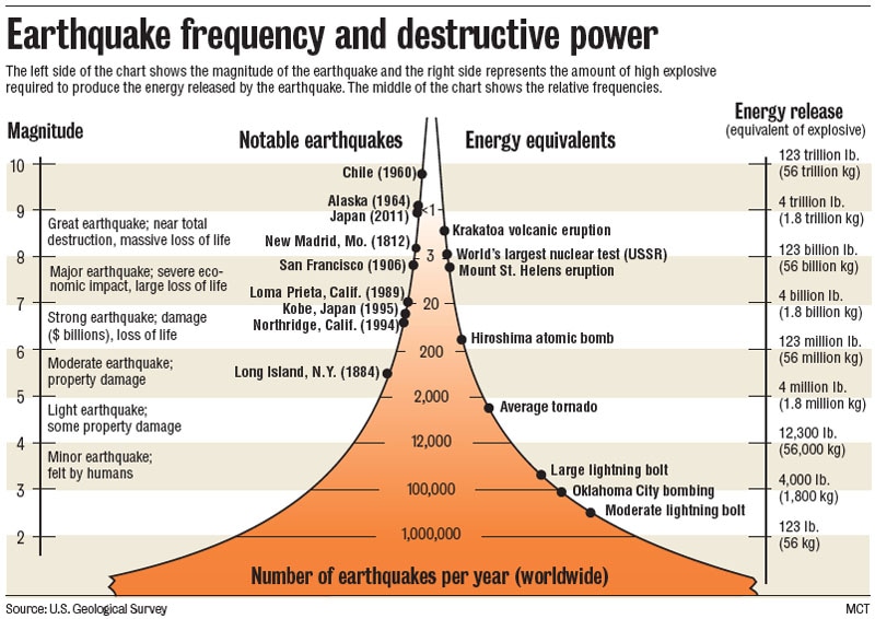
Task: Construct a table in Excel that tabulates the Location, Deaths and Magnitude (Richter Scale) for the earthquakes on the BBC site.
Produce a scattergraph from the data, plotting the number of deaths against the magnitude. Is there a relationship between the magnitude (Richter Scale) of an earthquake and the number of deaths it causes? |
|
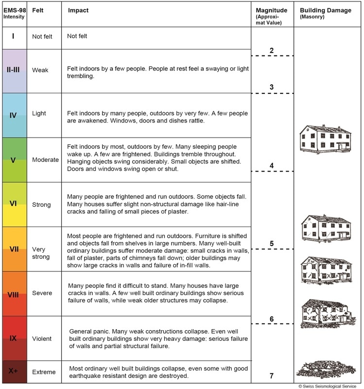
8.3 Damage: What affects the damage an earthquake causes
Task 8.1.1 In the video below, note down all the damage you see in your notebook.
|
|
|
Factors that effect the damage an earthquake causes are: population density, types of buildings, time of day, distance from the epicentre, types of rocks and sediments, secondary hazards and economic development.
| earthquake_damage.pdf |
Stop Disasters website Earthquake game
8.4 Earthquake Engineering
|
|
|
Key Terms:
Resonance
Oscillation
Frequency
Materials
Period
Resonance
Oscillation
Frequency
Materials
Period
Your task
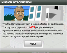
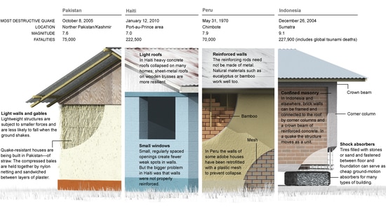
Investigate methods that engineers and architects use to make buildings resistant to earthquakes. Use that knowledge to design and model an Earthquake-proof building. This will then be presented as a sales pitch explaining the features of your earthquake-proof building.
Bonus points for buildings that are made most appropriate for a particular LEDC or MEDC. This might mean reflecting upon the types of earthquakes that occur in a given place, the suitability of the materials for the environment and the suitability of the design for the environment the building will be based in. This is not limited to skyscrapers in large cities - what about houses for people who live in rural villages or homes for people who are financially limited?
Requirements
1. Create a model building.
- Models must be between 50cms - 60cms tall.
- Bases of models can be no larger than 20cm edge-to-edge.
- A container for an egg to sit in must sit within 5cms of the top of the building.
- No planes of cardboard or any other material can be use to hide the frame of the structure, all materials used in the model must be appropriate equivalents of real-life materials.
- Most importantly, you must show your investigated earthquake-resistant feature(s).
- (Can be displayed in the sales booklet for clarity)
- Maximum 2 x A4 sheets. (4 pages)
- Font no smaller than 12 point, double spaced.
- Must include the bibliography.
- Pictures must be annotated and sourced.
|
|
|
9. The Tsunami
Key Terms:
- Tsunami
- Definition:A series of huge ocean waves generated by undersea earthquakes or landslides, volcanic eruptions, or the impact of a large meteorite in the sea.
- Context:The word "tsunami" comes from the Japanese term for great harbor wave.
- Crest
- Definition:The top of a wave
- Context:The crest of a wave may rise only a foot or two above normal.
- Surge
- Definition:A large wave or billow
- Context:The water builds and then breaks into a huge surge that rushes ashore.
- Trough
- Definition:The lowest point between waves
- Context:For every wave peak is a trough. If the trough appears first, the sea recedes before a wave arrives on land.
Source: http://school.discoveryeducation.com/lessonplans/programs/tsunami/
|
|
|
Task 9.1 Comic: You must create a comic that demonstrates how a tsunami forms, what happens when it reaches shore, what damage it does.
10 Worst Tsunamis
1. Sumatra, Indonesia - 26 December 2004
The 9.1 magnitude earthquake off the coast of Sumatra was estimated to occur at a depth of 30 km. The fault zone that caused the tsunami was roughly 1300 km long, vertically displacing the sea floor by several metres along that length. The ensuing tsunami was as tall as 50 m, reaching 5 km inland near Meubolah, Sumatra. This tsunami is also the most widely recorded, with nearly one thousand combined tide gauge and eyewitness measurements from around the world reporting a rise in wave height, including places in the US, the UK and Antarctica. An estimated US$10b of damages is attributed to the disaster, with around 230,000 people reported dead.
2. North Pacific Coast, Japan - 11 March 2011
A powerful tsunami travelling 800km per hour with 10m-high waves swept over the east coast of Japan, killing more than 18,000 people. The tsunami was spawned by an 9.0 magnitude earthquake that reached depths of 24.4km- making it the fourth-largest earthquake ever recorded. Approximately 452,000 people were relocated to shelters, and still remain displaced from their destroyed homes. The violent shaking resulted in a nuclear emergency, in which the Fukushima Daiichi nuclear power plant began leaking radioactive steam. The World Bank estimates that it could take Japan up to five years to financially overcome the $235 billion damages.
3. Lisbon, Portugal - 1 November 1755
A magnitude 8.5 earthquake caused a series of three huge waves to strike various towns along the west coast of Portugal and southern Spain, up to 30 m high, in some places. The tsunami affected waves as far away as Carlisle Bay, Barbados, where waves were said to rise by 1.5 m. The earthquake and ensuing tsunami killed 60,000 in the Portugal, Morocco and Spain.
4. Krakatau, Indonesia - 27 August 1883
This tsunami event is actually linked to the explosion of the Krakatau caldera volcano. Multiple waves as high as 37 m were propagated by the violent eruptions and demolished the towns of Anjer and Merak. The sea was reported to recede from the shore at Bombay, India and is said to have killed one person in Sri Lanka. This event killed around 40,000 people in total; however, as many as 2,000 deaths can be attributed directly to the volcanic eruptions, rather than the ensuing tsunami.
5. Enshunada Sea, Japan - 20 September 1498
An earthquake, estimated to have been at least magnitude 8.3, caused tsunami waves along the coasts of Kii, Mikawa, Surugu, Izu and Sagami. The waves were powerful enough to breach a spit, which had previously separated Lake Hamana from the sea. There were reports of homes flooding and being swept away throughout the region, with a total of at least 31,000 people killed.
6. Nankaido, Japan - 28 October 1707
A magnitude 8.4 earthquake caused sea waves as high as 25 m to hammer into the Pacific coasts of Kyushyu, Shikoku and Honshin. Osaka was also damaged. A total of nearly 30,000 buildings were damaged in the affected regions and about 30,000 people were killed. It was reported that roughly a dozen large waves were counted between 3 pm and 4 pm, some of them extending several kilometres inland at Kochi.
7. Sanriku, Japan - 15 June 1896
This tsunami propagated after an estimated magnitude 7.6 earthquake occurred off the coast of Sanriku, Japan. The tsunami was reported at Shirahama to have reached a height of 38.2 m, causing damage to more than 11,000 homes and killing some 22,000 people. Reports have also been found that chronicle a corresponding tsunami hitting the east coast of China, killing around 4000 people and doing extensive damage to local crops.
8. Northern Chile - 13 August 1868
This tsunami event was caused by a series of two significant earthquakes, estimated at a magnitude of 8.5, off the coast of Arica, Peru (now Chile). The ensuing waves affected the entire Pacific Rim, with waves reported to be up to 21 m high, which lasted between two and three days. The Arica tsunami was registered by six tide gauges, as far off as Sydney, Australia. A total of 25,000 deaths and an estimated US$300 million in damages were caused by the tsunami and earthquakes combined along the Peru-Chile coast.
9. Ryuku Islands, Japan - 24 April 1771
A magnitude 7.4 earthquake is believed to have caused a tsunami that damaged a large number of islands in the region; however, the most serious damage was restricted to Ishigaki and Miyako Islands. It is commonly cited that the waves that struck Ishigaki Island was 85.4 m high, but it appears this is due to a confusion of the original Japanese measurements, and is more accurately estimated to have been around 11 to 15 m high. The tsunami destroyed a total of 3,137 homes, killing nearly 12,000 people in total.
10. Ise Bay, Japan - 18 January 1586
The earthquake that caused the Ise Bay tsunami is best estimated as being of magnitude 8.2. The waves rose to a height of 6m, causing damage to a number of towns. The town of Nagahama experienced an outbreak of fire as the earthquake first occurred, destroying half the city. It is reported that the nearby Lake Biwa surged over the town, leaving no trace except for the castle. The Ise Bay tsunamis caused more than 8000 deaths and a large amount damage.
Task 9.2 Become an expert on 1 of the top 6 tsunami's.
- You have 10 minutes to learn as much as you can about the tsunami, prepare a presentation
- You will have to present your 2 minute presentation.
|
Watch "The Impossible" in class.
|
|
